Retrospective: June-August 2017 Outlook
The atmospheric circulation around New Zealand was forecast to favour more anticyclonic flows (high pressure) than normal to start the three month period of June – August 2017, bringing extended periods of settled weather. For June – August 2017 as a whole, the atmospheric circulation around New Zealand was forecast to favour slightly more westerly wind flows than normal, but variable circulation patterns were to be expected over the course of the winter season. Actual pressures were higher than normal to the southeast of the country and near normal across New Zealand. There was no significant airflow anomaly.
Predicted air temperature: June – August 2017 temperatures were about equally likely to be above average or near average for all regions of New Zealand.
Outcome: Actual temperatures were near average for much of the country. Pockets of above average temperature were observed in the Bay of Plenty, Coromandel and parts of the West Coast.
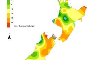
Predicted rainfall: June – August 2017 rainfall totals were likely to be near normal or below normal in the north of the North Island and east of the South Island. For all remaining regions of New Zealand, winter rainfall totals were most likely to be near normal.
Outcome: Actual rainfall was near normal for much of the country. Above normal rainfall was recorded for eastern parts of the South Island from Christchurch down to Balclutha.