Retrospective: April-June 2017 Outlook
During April-June, the atmospheric circulation around New Zealand was expected to favour higher pressure than normal to the west of the country, with more anticyclonic south-westerly wind flows than normal, a pattern suggestive of El Niño. However, in April 2017 as the season starts, it was expected that New Zealand will be influenced by active sub-tropical disturbances, potentially producing heavy rainfall, and frequent wind flows from the north. Actual pressures were higher than normal over the country, particularly to the south-east. This pressure set up led to more easterlies than normal.
Predicted air temperature: April – June 2017 temperatures were most likely to be above average in the north of the North Island, and about equally likely to be above average or average for all other regions of New Zealand.
Outcome: Actual temperatures were above average in Northland, Auckland, eastern Waikato and the Bay of Plenty as well as parts of Gisborne, Hawke’s Bay and the West Coast. Temperatures were near average elsewhere.
Predicted rainfall: April – June 2017 rainfall totals were about equally likely to be above normal or near normal in the north of both Islands. Conversely, rainfall was about equally likely to be below normal or near normal in the west of the South Island. For other regions, near normal rainfall was the most likely outcome.
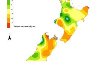
Outcome: Actual rainfall was above normal for much of the North Island as well as northern and coastal eastern parts of the South Island. Rainfall was below normal for large parts of Otago, Southland and the West Coast.