Retrospective: March-May 2017 Outlook
During March-May, the likely persistence of ENSO-neutral conditions and intermittently active periods in the Madden-Julian Oscillation, changeability in New Zealand’s weather patterns was expected to occur. The atmospheric circulation around New Zealand was expected to favour more westerly wind flows than normal. Actual pressures were higher than normal over and to the southwest of the country, this pressure set up resulted in more easterly to north-easterly winds than normal.
Predicted air temperature: March – May 2017 temperatures were about equally likely to be average or above average in the north and east of both the North and South Island. In the west of both Islands, temperatures were most likely to be near average.
Outcome: Actual temperatures were above average for much of the North Island, the exceptions were the Greater Wellington Region and the Tararua district where near average temperatures were recorded. In the South Island, temperatures were mostly near average apart from the West Coast where above average temperatures were observed.
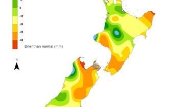
Predicted rainfall: March – May 2017 rainfall totals were about equally likely to be near normal or below normal in all regions of the country except the west of the South Island where near normal rainfall was most likely.
Outcome: Actual rainfall was above normal for the entire North Island and the north and east of the South Island. This pattern was driven by a handful of extreme rainfall events in March and April. In the west of the South Island, rainfall was below normal.