Three-month outlook

Tropical rainfall and SST outlook: November 2008 to January 2009
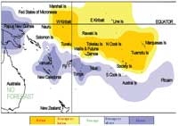
Rainfall outlook map for November 2008 to January 2009. (Click for enlargement)
Sea surface temperature outlook map for November 2008 to January 2009.

Tropical rainfall and SST outlook: November 2008 to January 2009

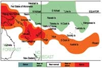
Rainfall outlook map for November 2008 to January 2009. (Click for enlargement)
Sea surface temperature outlook map for November 2008 to January 2009. (Click for enlargement)

During the November 2008–January 2009 forecast period, a region of suppressed convection is likely to encompass the central and eastern Southwest Pacific, in a region extending from Western Kiribati to the Marquesas Islands and the Society Islands, including Tuvalu, Tokelau, Wallis & Futuna, Samoa, the Northern Cook Islands, and the Tuamotu archipelago. Below normal or near–to–below normal rainfall is expected for those countries.

Enhanced convection is expected to be focused near Papua New Guinea, and also near Vanuatu, New Caledonia, Tonga, Fiji, and Niue with above average rainfall. Near–to–above average rainfall is forecast for the Southern Cook Islands, the Austral Islands, and Pitcairn Island for the next three-month period. No clear precipitation forecast is offered for the Solomon Islands.

SSTs are expected to be above normal in a band extending from near Papua New Guinea, southeast to Fiji, including Vanuatu, New Caledonia, and the Solomon Islands. Near – above normal SSTs are forecast for Niue, the Southern Cook Islands, the Austral Islands and Pitcairn Island. Normal to below normal SSTs are forecast for the northeastern sector of French Polynesia, including the Tuamotu archipelago and the Society Islands, Tuvalu, Tokelau, and both Eastern and Western Kiribati.

The confidence in the forecast model skill for this seasonal rainfall outlook is moderately high for most Pacific Island countries. In the past, the average region-wide hit rate for forecasts issued in November is 64%, 4% higher than the long-term average for all months combined. The SST forecast confidence is moderate for this period.

Island group Rainfall outlook Outlook confidence
Papua New Guinea 20:30:50 (Above) Moderate - high
New Caledonia 20:35:45 (Above) Moderate - high
Niue 20:35:45 (Near to above) Moderate - high
Tonga 20:35:45 (Above) Moderate - high
Vanuatu 20:35:45 (Above) Moderate - high
Fiji 25:35:40 (Near or above) Moderate
Austral Islands 25:35:40 (Near or above) Moderate - high
Cook Islands (Southern) 25:35:40 (Near or above) Moderate - high
Pitcairn Islands 25:35:40 (Near or above) Moderate - high
Solomon Islands 30:35:35 (Climatology) Moderate - high
Kiribati (Eastern) 40:35:25 (Near or below) Moderate - high
Samoa 40:40:20 (Near or below) Moderate
Cook Islands (Northern) 40:35:25 (Below) Moderate - high
Wallis & Futuna 45:35:20 (Below) Moderate
Marquesas Islands 45:30:25 (Below) Moderate
Kiribati (Western) 45:30:25 (Below) Moderate
Society Islands 50:30:20 (Below) Moderate - high
Tokelau 50:30:20 (Below) Moderate - high
Tuamotu Islands 50:30:20 (Below) Moderate - high
Tuvalu 50:30:20 (Below) Moderate - high
Island group SST Outlook Outlook confidence
Fiji 20:35:45 (Above) Moderate
New Caledonia 20:35:45 (Above) Moderate
Papua New Guinea 20:35:45 (Above) Moderate
Vanuatu 20:35:45 (Above) Moderate
Austral Islands 20:40:40 (Near or above) Moderate
Cook Islands (Southern) 20:40:40 (Near or above) Moderate
Pitcairn Islands 20:40:40 (Near or above) Moderate
Samoa 20:40:40 (Near or above) Moderate
Wallis & Futuna 20:40:40 (Near or above) Moderate
Niue 25:35:40 (Near or above) Moderate
Solomon Islands 25:35:40 (Near or above) Moderate
Tonga 25:35:40 (Near or above) Moderate
Society Islands 30:45:25 (Near normal) Moderate - high
Tuamotu Islands 30:40:30 (Near normal) Moderate - high
Cook Islands (Northern) 35:40:25 (Near or below) Moderate - high
Marquesas Islands 35:40:25 (Near or below) Moderate
Tokelau 35:40:25 (Near or below) Moderate - high
Tuvalu 35:40:25 (Near or below) Moderate - high
Kiribati (Eastern) 40:35:25 (Near or below) Moderate
Kiribati (Western) 40:40:20 (Near or belowl) Moderate

NOTE: Rainfall estimates for Pacific Islands for the next three months are given in the table. The tercile probabilities (e.g., 20:30:50) are derived from the interpretation of several global climate models. They correspond to the odds of the observed rainfall being in the lowest (driest) one third of the rainfall distribution, the middle one third, or the highest (wettest) one third of the distribution. On the long-term average, rainfall is equally likely (33% chance) in any tercile.