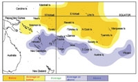
Tropical rainfall outlook: January 2008 to March 2008

La Niña conditions are still very likely to influence rainfall patterns during this period, with a large area of suppressed convection very likely along the equatorial Pacific from Western Kiribati to Eastern Kiribati, including Tuvalu, the Northern Cook Islands, the Marquesas, and the Tuamotu Islands. Near or below average rainfall is likely for the Solomon and Society Islands.
Average rainfall is likely for Papua New Guinea, Samoa and the Tokelau Islands.
Enhanced convection with above average rainfall is likely from Vanuatu through to Pitcairn Island, including NewCaledonia, Fiji, Wallis and Futuna, Tonga, Niue, and the Southern Cook Islands. Near or above average rainfall is likely in the Austral Islands.
The confidence in the forecast model skill for this seasonal outlook is moderate to high for most Pacific Island countries. In the past, the average region-wide hit rate for forecasts issued in December has been 66%, 5% higher than the long term average for all months combined.
| Island group | Rainfall outlook | Outlook confidence |
|---|---|---|
| Tonga | 20:25:55 (Above) | High |
| Southern Cook Islands | 15:30:55 (Above) | High |
| Niue | 20:30:50 (Above) | High |
| Pitcairn Islands | 20:30:50 (Above | High |
| Vanuatu | 20:35:45 (Above) | High |
| New Caledonia | 20:35:45 (Above) | High |
| Fiji | 20:35:45 (Above) | High |
| Wallis & Futuna | 20:35:45 (Above) | Moderate |
| Austral Islands | 20:40:40 (Near or Above) | Moderate - high |
| Papua New Guinea | 30:40:30 (Near Average) | Low |
| Samoa | 25:45:30 (Near Average) | Moderate - high |
| Tokelau | 30:40:30 (Near Average) | Low |
| Solomon Islands | 40:40:20 (Near or Below) | Moderate |
| Society Islands | 40:40:20 (Near or Below) | Moderate |
| Tuamotu Islands | 50:30:20 (Below) | High |
| Tuvalu | 55:30:15 (Below) | High |
| Northern Cook Islands | 55:30:15 (Below) | High |
| Marquesas Islands | 55:30:15 (Below) | High |
| Eastern Kiribati | 60:25:15 (Below) | High |
| Western Kiribati | 60:25:10 (Below) | High |
NOTE: Rainfall estimates for Pacific Islands for the next three months are given in the table. The tercile probabilities (e.g., 20:30:50) are derived from the interpretation of several global climate models. They correspond to the odds of the observed rainfall being in the lowest (driest) one third of the rainfall distribution, the middle one third, or the highest (wettest) one third of the distribution. On the long-term average, rainfall is equally likely (33% chance) in any tercile.
Tropical cyclones
Tropical cyclone Daman, the second this season, affected parts of Fiji between 5-9 December, with estimated maximum sustained wind speeds on the 7th of 195 km/h (category 3 on the Saffir-Simpson scale). Heavy rainfall,exceeding 100 mm, occurred over northern Fiji with the passage of the cyclone. Damage was severe north of Vanua Levu, Fiji.
The moderate La Niña conditions presently affecting the Pacific will continue to influence tropical cyclones in several parts of the South Pacific this season. The period January through March is normally the most active part of the Southwest Pacific tropical cyclone season.
