Climate developments in September 2007

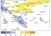
The South Pacific Convergence Zone (SPCZ) extended from Papua New Guinea to the region south of Tonga, including the Solomon Islands, Vanuatu, and Fiji, being very active and much further southwest than normal for the time of year. An elongated region of suppressed convection continued to persist along the equator from Western and Eastern Kiribati and further east (north of the Equator) toward the coast of South America. Suppressed convection also affected Tuvalu and the northern Cook Islands.
Rainfall was extremely high in areas under the active SPCZ with over 200% or more of normal in Vanuatu, NewCaledonia and much of Fiji, and also above normal in Papua New Guinea, Solomon Islands, Samoa and southern parts of Tonga. For New Caledonia, it was the 3rd wettest September on record. In Fiji several sites had their wettest September on record, with a few sites recording more than 400% of normal rainfall. In contrast rainfall was extremely low in the equatorial region with 50% or less of normal throughout Kiribati, the northern Cook Islands and the Marquesas Islands, and also below normal in Tuvalu, Tokelau and Niue. Rainfall was close to normal on Tonga.
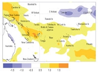
September mean air temperatures were 1.0 ºC or more above normal in many southwest Pacific tropical islands south of latitude 10ºS. Temperatures were 0.53.0 °C above normal in Fiji with many sites having their warmest September on record, as well as the highest individual daily maximum extremes (33.0 °C at Viwa Island) and warmest minimums ever.
Tropical Southwest Pacific mean sea-level pressures werebelow average west of the Date Line, especially in the New Caledonia-Vanuatu region. Higher than normal pressures occurred over the Tasman Sea, New Zealand, and the region south of central French Polynesia in the east.
Equatorial surface easterlies have strengthened since August between 140ºE and 160ºW occurring in over 75% of observations at Tarawa.
| Country | Location | Rainfall (mm) | % of average | Comments |
|---|---|---|---|---|
| Vanuatu | Lamap | 285 | 380 | Well above average |
| Vanuatu | Aneityum | 400 | 500 | Highest on record |
| New Caledonia | Poindimie | 419 | 455 | Highest on record |
| Fiji | Labasa | 350.3 | 487 | Highest on record |
| Fiji | Levuka | 384.5 | 447 | Highest on record |
| New Caledonia | Moue | 314 | 532 | Highest on record |
| Kiribati | Tarawa | 19 | 15 | Extremely low |
| French Polynesia | Atuona | 16 | 22 | Extremely low |
| Cook Islands | Penrhyn | 24 | 16 | Well below average |
| Country | Location | Mean temp.(°C) | % of average | Comments |
|---|---|---|---|---|
| Fiji | Nadi | 26.7 | +2.4 | Extremely high |
| Fiji | Laucala Bay | 26.0 | +1.9 | Extremely high |
Soil moisture in September 2007

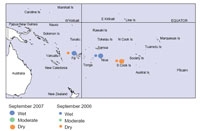
Estimates of soil moisture shown in the map (right) are based on monthly rainfall for one station in each country. Currently there are not many sites in the water balance model. It is planned to include more stations in the future.
The information displayed is based on a simple water balance technique to determine soil moisture levels. Addition of moisture to available water already in the soil comes from rainfall, and losses via evapotranspiration. Monthly rainfall and evapotranspiration are used to determine the soil moisture level and its changes.
Please note that these soil moisture calculations are made at the end of the month. For practical purposes, generalisations were made about the available water capacity of the soils at each site.
At the end of September 2007, soils were moist (at field capacity) for the time of year at both Nadi (Fiji) and Hanan(Niue), while soils were dry at Rarotonga.
El Niño/Southern Oscillation (ENSO)


La Niña conditions have become more developed in the tropical Pacific during September.
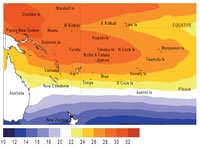
Sea surface temperatures (SST) in the equatorial Pacific became more strongly negative east of 140°W, and the cold area anomaly expanded west as far as the Date Line. A warm horseshoe is continuing to develop in the extratropics of both hemispheres in the western Pacific. This is also evident during September in the sea surface height anomalies. The NINO3anomaly was -0.9 °C in September (JAS average -0.7) and the NINO4 anomaly is now negative for the first time since early 2006, at -0.1°C for September (JAS average +0.2 °C). There are significant equatorial subsurface negative temperature anomalies, with an extensive 2 °C below average region at 100 metres in the eastern Pacific, with positive anomalies (+1 °C) in the same layer west of the Date Line.
Equatorial easterly wind anomalies strengthened around and east of the Date Line. The SOI in September is still neutral (+0.1) with a JAS average of -0.1.
Tropical OLR anomalies show suppressed convection from west of the Date Line right across the Pacific north of the equator. The TRMM-based ENSO precipitation index has become more negative, and is -0.9, in the weak La Niña range. The SPCZ was very active and displaced south west. The Madden-Julian Oscillation (MJO) is very weak at present.
Overall, these show a La Niña in progress withcoupling between the ocean and atmosphere between the warmer western Pacific and cooler eastern Pacific. Convective coupling has also occurred to a limited degree with increased convection in Papua New Guinea.
Model forecasts have strengthened, with eight of the nine dynamical models indicating La Niña conditions through to February 2008. Only two of the six statistical models have singled out the developing cold conditions. These suggest the current event peaking towards the end of the year.
The NCEP synopsis suggests La Niña conditions will develop further during the next 3 months. The IRI synthesis gives a probability of 65% for a La Niña for the remainder of the year. The probability of El Niño conditions re-emerging during the forecast period remains at or below 10% until AMJ 2008, with the probability of returning to ENSO-neutral below 50% during 2007.
Forecast validation: July to September 2007
Enhanced convection and above average rainfall were expected over Samoa and the Northern Cook Islands, with near or above average rainfall forecast from the Solomon Islands southeast to French Polynesia, including Vanuatu, Fiji, Tonga, Wallis and Futuna, Niue, and the Southern Cook Islands.
Suppressed convection with below average rainfall was expected over Western and Eastern Kiribati, with near or below average rainfall in Tokelau and Tuvalu. Near average rainfall was expected elsewhere.
Suppressed convection and below average rainfall occurred as expected in the equatorial region about and east of theDate Line, including Western and Eastern Kiribati and Tuvalu. Rainfall was also below average in the Cook Islands and the Marquesas (lower than expected). Lower than expected rainfall occurred in Niue and the Society Islands. Rainfall was above average from Papua New Guinea to Tonga (asexpected) and in New Caledonia (wetter than expected), and average to above average in Fiji (as expected). The 'hit' rate for the July-September 2007 rainfall outlook was about 59%.
