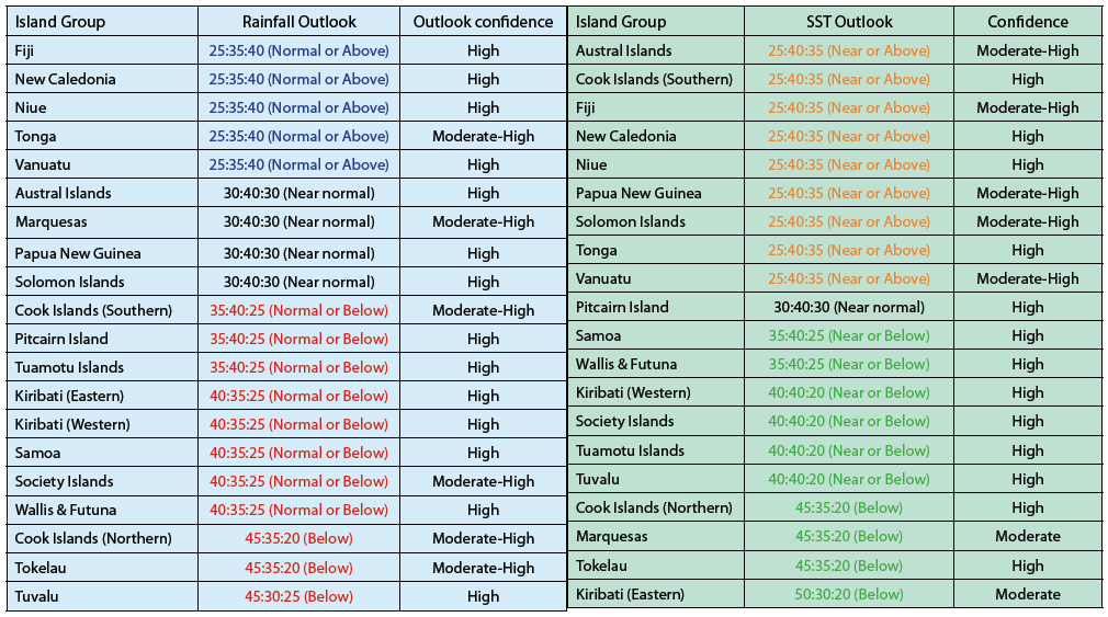
A Nina pattern is still expected in the ensemble of global climate forecasts over the forecast period, even though there are indications that a transition to neutral conditions might occur by mid–autumn.
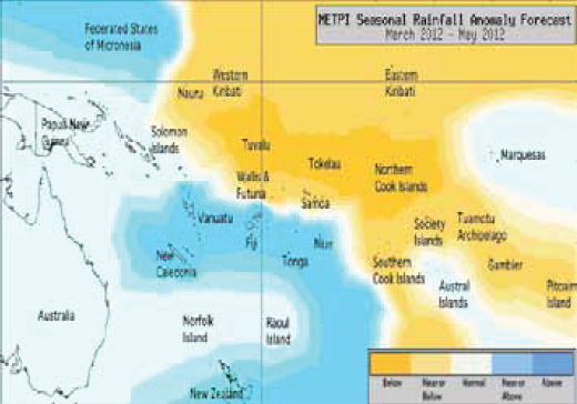
The South Pacific Convergence Zone is shifted to the Southwest and suppressed convection is expected near Tuvalu, Tokelau, and the Northern Cook Islands which are likely to receive below normal rainfall in the coming three months.
Average or below average rainfall is expected for the Tuamotu Archipelago, Eastern and Western Kiribati, the Society Islands, Samoa, Pitcairn Island, the Southern Cook Islands and Wallis & Futuna.
Near or above average rainfall is forecast for Fiji, New Caledonia, Niue, Tonga and Vanuatu. Near normal rainfall is expected for the Austral Islands, Marquesas, Papua New Guinea and the Solomon Islands.
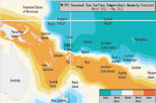
La Niña SSTa signals that have existed in past months are easing in the global model ensemble. For the coming three months, cool sea surface anomalies are expected along and south of the Equator to the east of the Dateline encompassing Eastern Kiribati, the Northern Cook Islands, Tokealu and the Marquesas.
Below normal SSTs are expected for those island groups. Normal osr below normal SSTs are forecast for Western Kiribati, Wallis & Futuna, Tuvalu, the Tuamotu Archipelago, the Society Islands, and Samoa.
Near normal or above normal sea surface temperatures are forecast for Papua New Guinea, the Solomon Islands, New Caledonia, Vanuatu, Fiji, Tonga, the Austral Islands, the Southern Cook Islands and Niue. Near normal SSTs are forecast for and Pitcairn Island.
The confidence for the rainfall outlook is high or moderately high. The average region–wide hit rate for rainfall forecasts issued in March is 63%, equal to the long–term average for all months combined. The SST forecast uncertainty is greatest near the Marquesas and Eastern Kiribati.