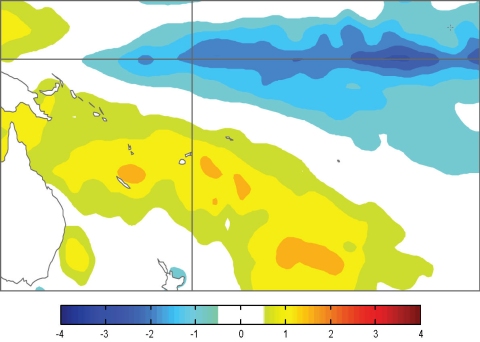
A moderate to strong La Niña event is in place in the tropical Pacific.
There is enhanced convection over Indonesia and northern Australia, while convection remains suppressed near the equator in the western and central Pacific. The ITCZ and SPCZ are both displaced poleward of their normal position. The TRMM ENSO index was –1.4 for October, similar to September (values of –1.0 or less are considered typical of La Niña conditions). Easterly trade winds have been stronger than normal west of about 160°W. The SOI has been near or above +2.0 for the past four months, and stood at +1.8 for October and +2.1 for the three-month mean for August – October 2010. A pronounced cold tongue extends along the Equator from 160°E to the South American coast, with positive SST anomalies in the far western Pacific and in the extra–tropics of both hemispheres. The NINO3 and NINO4 anomalies continue to strengthen, and were around 1.6°C and –1.2°C respectively for October (ASO averages of –1.1°C and –1.0°C, respectively). A strong negative subsurface heat content anomaly is centred near 140°W and is migrating eastwards, with a positive anomaly strengthening in the western Pacific. A weak MJO convective anomaly is slow-moving over the Indonesian region and may persist for the coming two weeks.
All of the dynamical and statistical models NIWA monitor predict the tropical Pacific to be in a La Niña state over the coming three months. Most models project the La Niña until February – April 2011, with a rapid weakening after that time. The NCEP ENSO discussion of 7 October states that La Niña conditions are expected to persist at least through southern autumn 2011. The IRI summary of 21 October indicates a 99% probability for moderate-strong La Niña conditions continuing through to December 2010, 95% through February 2011, and at least 50% until April–June 2011.

Surface temperature anomalies (ºC) for October 2010
