El Niño/Southern Oscillation (ENSO)
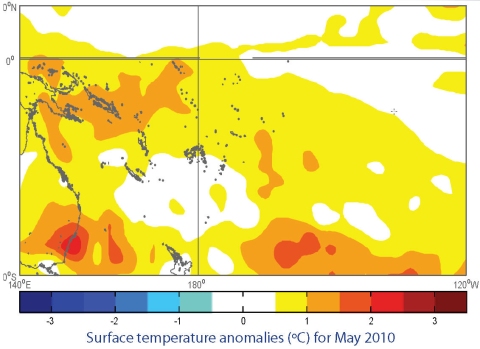
The recent El Niño event has ended, and the tropical Pacific is now in an ENSO–neutral state. Cool anomalies have now appeared at the surface in the equatorial mid– Pacific, and the NINO3 and NINO4 regions have eased to around +0.7°C and +0.5°C, respectively, for May (MAM averages of +0.8°C and +0.9°C, respectively). A large cool region has developed in sub-surface waters east of the Dateline, of at least 3°C colder than normal. The only warmer-than-normal waters in the equatorial Pacific are shallow surface layers around and west of the Dateline and near South America. Clear changes are also apparent in the atmosphere. The SOI has maintained a positive value at +1.0 for May, after its abrupt rise to +1.7 in April from previous negative values. The running 3–month mean SOI is now positive for the first time since July 2009. Tropical OLR anomalies for May showed enhanced convection near Indonesia and northern Australia, and an expanded area of suppressed convection near the Dateline. The 30-day mean TRMM ENSO index at 25- May was –0.6 (values of –1.0 or less are typical of La Niña conditions). The trade winds were generally near normal or slightly stronger than normal in May across most of the Equatorial Pacific. The MJO was weak at the end of May.
All the models NIWA monitor forecast the tropical Pacific to continue to cool over coming months, with 7 out of 10 dynamical models suggesting La Niña will develop by Austral spring (SON 2010). The NCEP ENSO discussion of 6 May suggests ENSO-neutral conditions through the Austral winter season. The IRI summary of 20 May indicates the probability of La Niña will increase from 13% for May-July to 42% for the period August-October.

