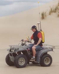
NIWA operates two Trimble RTK (real-time kinematic) GPS systems – the 5700 and R8.
These global positioning systems are capable of measurements with an accuracy of 10mm in the horizontal and 20 mm in the vertical and allow NIWA to undertake highly precise topographic surveys.
When paired with one of NIWA's highly accurate depth sounders (Tritech PA500 and Ohmex Sonarmite BT), we are able to conduct high resolution and high precision bathymetric surveys – either from a jet boat or a customized kayak for shallow river surveys. This enables us to measure beach stability, river bed erosion and deposition and to create digital terrain models of rivers for 2-dimensional hydrodynamic modelling.
📸 A GPS station in use. [K. Smith]

